Southborough's Own Gasworks

The material in this article was first published in Southborough Spotlight in an article written in March 1973 by that fine local historian, Doug Bennett. It was prompted then by a dispute in the gas industry. Now, in 2022, energy supplies and rising prices are in the news once more. We are reprinting an abridged version of the original article.
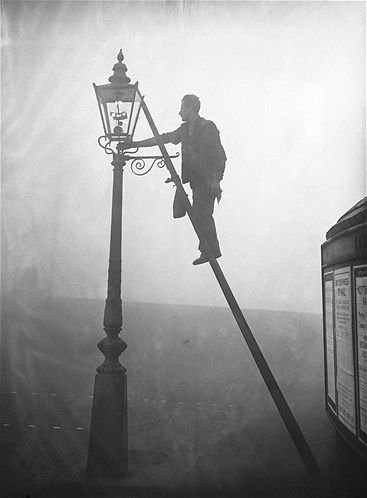
A lamplighter.

Southborough had its own gas works by 1858, sited at the end of Speldhurst Road and clearly marked on the OS map of that year. Gas was expensive in those days and was only used for domestic lighting for those who could afford it.

Site of the former gasworks on Speldhurst Road.

In 1871, a proposal was made in a Council meeting, that the Gas Company should be asked to tender for lighting Southborough’s highways. In spite of some concerns about the financial viability of the Company the tender was accepted. The Gas Company agreed to erect 38 lamps and columns, to light and extinguish these lamps and to keep them properly lit from an hour after sunset until 10.30 each night, except for the five nights nearest each new moon. Obviously, it was assumed people would be safely tucked in bed after 10.30! Additionally, the lamps would not be lit between May 15th and August 15th. The annual cost of each lamp was £2. 14. 0.

The “opening ceremony” on August 16th 1871, in celebration of the coming of the lights, featured a torchlight procession and was attended by an estimated crowd of 4,000. No doubt it was an exciting public spectacle.

Rare, undated photograph of the gasworks, circa late 19th century.

Rare, undated photograph of the gasworks, circa late 19th century.

It seems as if the gas street lights weren’t an unqualified success. By 1877, the Council Lighting Committee was experimenting with paraffin oil lamps, which it was thought might prove superior to the gas lamps. Six were ordered for use near St. Peter’s Church. The number of street lights in the town increased gradually, two more being added in 1878. In 1880 Vulcan (Vale), Meadow, Bedford and Forge Roads were all illuminated. Six more lights were added elsewhere in 1883. By 1890 lamplighters were paid 8/6d per week for their services in lighting and then quenching the street lamps.

Rare, undated photograph of the gasworks, circa late 19th century.

Electric lighting was close on the horizon and two companies providing that service endeavoured to impress the Lighting Committee, with no initial success. High Brooms continued to depend on oil lamps for several more years, as the Southborough Gas Works could not provide supplies. Eventually, High Brooms had to turn to the Tunbridge Wells Gas Company for their gas lights.

In the 1890s, gas heating and cooking appliances were sold by the Council and evening classes were held, in order to show how to cook by gas. Range cookery was so very different that there would be a good deal to learn. By 1897 it became necessary to buy gas in bulk from Tunbridge Wells until 1921, when the Southborough Gas Company ceased to exist, having been bought outright by the Tunbridge Wells Company.

If anyone is able to tell us when the gasworks was demolished or any other related information or photographs, please do get in touch thesouthboroughsociety@gmail.com

St Thomas Church: Its history and its people

An early 20th century hand coloured postcard of St Thomas Church, note the Martin Bootmaker shop on the corner of Pennington Road and Castle Street.

The church of St Thomas on Pennington Road has a fascinating history and connections to local people. Roger Evernden, who has published a book detailing its history will be presenting an illustrated talk and tour of the church on Tuesday, 19th of April at 7:30pm. All are welcome to the talk and there will be refreshments afterwards.

A little about St Thomas Church:

St. Thomas's Church was built at the sole expense of local resident, Mrs. Sarah Pugh, at a cost of £2,400 and it was consecrated by the Archbishop of Canterbury in 1860.

The memorial dedicated to Mrs Sarah Pugh who solely financed the construction of the church.

The church has been extended and altered over the years. The main additions have been, the North Aisle (1879), the Choir Vestry (1881), the "Colebrooke Chapel" (1889), the West Porch (1909), the North Transept and Organ Loft (1925) and the Baptistery (1939).

The St. Thomas window in the north aisle dates from 1879 and is in memory of Mrs. Blackburn Maze. The windows in the sanctuary were also given by the Blackburn Mazes. The windows in the "Colebrooke Chapel" all depict subjects from the Gospel of St. Lukę, "the beloved physician" - Henry Colebrooke was a local doctor.

The picture above the Lady Chapel is a copy of Botticelli's "Our Lady of the Magnificat" and was presented to the church in 1923.

The oak choir stalls were carved by resident of Vale Road, William Wallis, a man with deep connections to Southborough, you can read all about him here.

The present organ was given in 1925 and the organ loft was built to accommodate it. The organist sat in the "gondola" above the choir stalls. The organ was rebuilt and a new console provided in the 1980s. There have been ten vicars and they are listed in the south aisle. The memoriał to the right of the church door is to the Revd. Henry Julian Bigsby, the first vicar of the parish, 1870 - 1890, see image below. The churchyard has never been used for burials and is maintained as a garden.

Milestones: Markers Along the Way

The Southborough milestone today.

Our thanks to member, Jo Carlill, who has contributed this article.

There is a lovely example of a 19th century milestone in Southborough, just up from The Hand & Sceptre on the eastern side of London Road. It is usually hidden amongst the undergrowth, roughly opposite the junction with Church Road, although it has recently been easy to find as the grass burying it has been cut back. The milestone shows a metal plate attached to a stone post. It marks LONDON 33 TUNBRIDGE 3. (Until the mid-1800s, Tonbridge was regularly spelt ‘Tun…’. By the 1870s it was more commonly spelt ‘Ton…’ but it wasn’t officially changed to Tonbridge until 1893). I wonder how often the word milestone is used without stopping to think of its origins?

Here is a dictionary definition:

Milestone: noun 1. A stone by the side of the road that shows how far it is to the next town, and to other places 2. A very important stage or event in the development of something.

In days gone by, these markers would have informed travellers of distances covered on a journey and the distance remaining. They also reassured them that they were on the correct road. An inscribed milestone pillar in Frant, displaying 2 MILES TO T.WELLS, can be seen in George Smart’s picture Old Bright, The Postman of c1830s (below).

Old Bright, The Postman by George Smart, c.1830s. ©Tunbridge Wells Borough Council t/a The Amelia.

According to the Milestone Society, the need to record distance on important roads goes back to Roman times when every 1000 double steps was recorded with a tall cylindrical stone at the side of the road. The distance marked was 1618 yards, close to the modern mile of 1760 yards. The Latin for thousand was mille. With the advent of the turnpike road in the 18th century, these milestones became compulsory on all major roads. They are marked on early maps as ‘MS’ for milestone or ‘MP’ for milepost and come in a multitude of shapes and decorative styles. Their existence is still recorded on modern Ordnance Survey maps by the initials ‘MS’.

You can also see the miles clearly marked on Hasted’s Hundred of Wachlingstone map of 1778, marking the distance from London. There is a 31M marker in Tunbridge (Tonbridge) at the bottom of Quarry Hill, just south of the road to Hayesden and the 32M marker can be seen further up Quarry Hill just before the road to Bidborough. Interestingly, the current Ordnance Survey map for this area, still marks the position of the 32M milestone (MS) on the eastern side of the A21, just north of the turning to Mabledon Farm. The stone is still there in the undergrowth. The current map does not mark the milestone by the Common.

Hasted’s map of 1778.

The 33M marker is on Hasted’s separate map showing the Lowy of Tunbridge (next image below). Here the miles have been measured to a point opposite what was once Stemps Farm ( now known as The Weavers). According to the Milestone Society, the Southborough milestone at the top of the Common was erected by the Tonbridge Turnpike Trust in the 19th century, so either the 18th century cartographer mistakenly marked it to the north of the wrong area of ‘green’, or perhaps the marker was moved half a mile north, as the road surface to London was improved and the route made more direct. The 33M point would have been a useful staging post close to a coaching inn, The Hand and Sceptre, and opposite the Common.

Hasted’s map showing 33M marker.

Until a few years ago, a sign denoting the Ostler’s post, where he would have waited to take charge of a horse which needed resting, was clearly visible on the wall of the Hand and Sceptre. The road here used to be wider and the remains of a brick pavement and/or edging is still just visible, in the grass on the western side of the road, where the horses used to wait.

The 1820s and 30s were considered to be the ‘Golden Age of Coaching’ with Turnpike Trusts being responsible for about 20,000 miles of roads in England and Wales. The demise of the “Golden Age” only came about with the arrival of the railway.

Examples of tolls charged at East Grinstead in 1784 were recorded as follows:

• For every Horse, Mule or Ass, laden or unladen, and not drawing 1d

• For every Chaise, or other such like Carriage, drawn by One Horse only 2d

• For every Coach, Chariot, Landau, Berlin, Hearse, Chaise, Calash or other such like Carriage, drawn by Two or more Horses 6d

• For every Cart, Dray or other such like Carriage 2d (Source: The Turnpike Roads of Ashdown Forest by Martin Berry).

According to the Milestone Society ‘Milestone’ is “a generic term, including mileposts made of cast iron. From 1767, mileposts were compulsory on all turnpike roads, not only to inform travellers of direction and distances, but to help coaches keep to schedule and for charging for changes of horses at the coaching inns. The distances were also used to calculate postal charges before the uniform postal rate was introduced in 1840. At the height of the turnpike era, there were 20,000 miles of roads with milestones.

Such way-markers are fast disappearing; around 9,000 are thought to survive in the UK. Most were removed or defaced in World War II to baffle potential German invaders and not all were replaced afterwards. Many have been demolished as roads have been widened or have been victims of collision damage.”

The Southborough milestone has been recorded by Kent County Council as a ‘non-designated heritage asset’. So, whilst it does not have listed or protected status, it has at least been noted as an object of historical interest. The grass verge, on which it is sited, is privately owned. Perhaps, next time you celebrate a milestone birthday or pass the Southborough milestone, you can remember the origins of the word and the important role this humble little way-marker once played for anyone travelling through the ‘south borough’ of what was then known as Tunbridge.

Hello Little Dormice!

One of the dormice boxes in situ on Doctor’s Meadow.

One of the dormice boxes in situ on Doctor’s Meadow.

After commissioning the Kent Wildlife Trust to undertake a survey of Southborough Society’s land adjoining the Common, Doctor’s Meadow, they suggested that endangered Hazel Dormice could inhabit the site and that this should be encouraged.

Britain’s dormice population has declined a huge 51% since 2000 and are now predominantly confined to Southern England and Wales.

So to help these little guys out we initiated a project in collaboration with the 2nd Southborough Brownies to construct nest boxes for the dormice to use in the Spring/Summer. The Brownies created thoughtful poems that were inscribed on the base of the nest boxes (we heard the mice are big poetry fans! ).

A message inscribed on the base of the nest box.

A message inscribed on the base of the nest box.

The pandemic put a pause on our activity but we are pleased to inform you all of the boxes are installed and ready for their new house guests! Next year we will be able to survey to see if any dormice have made a home in the boxes. They are mostly completely out of view as they should not be touched or disturbed, but you can see some images here of the boxes on the Meadow.

We’d like to thank Alsford Timber, Tonbridge for donating the materials to support this project and the biggest thank you to the 2nd Southborough Brownies who created the poems and made the boxes. Thank you also to Brown Owl Avril and Tinkerbell Sharon. Finally, thank you to Ian Johnstone at Kent High Weald Partnership for his advice and help installing the boxes.

HipstamaticPhoto-651137656.097873.JPG